
Banxi Gr
Type Locality and Naming
The name Banxi Gr derived from the Banxi System named by Wang Xiaoqing (H. C. Wang) and Liu Zuyi in 1936. The typical section is located in Banxi village; 60 km northwest of Yiyang County, Hunan Province (now belongs to Taojiang County). At present, the representative sections are situated in Madiyi (Yuanling County) and Yuxikou (Zhijiang County), Hunan Province.
[Figure: The type section of the Banxi Group in Hunan Province]
Synonym: (板溪群)
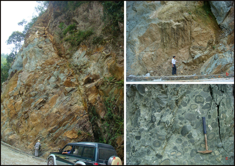
Lithology and Thickness
In the Linxiang to Shimen district, the Banxi Gr is imperfect and dominated by purplish red psepholite (=gritstone to conglomerate) and silty slate, which represents the coastal fluvial to delta deposit, with thickness of 300 to 700 m.
In the Yueyang-Huaihua district, the Banxi Group is perfect and composed of greenish gray, purplish red slightly metamorphosed conglomerate, sandstone, slate, tuffite, carbonate rock and carbonaceous slate, which constituted two large cycles. The older is represented by the Madiyi Fm and the younger is the Wuqiangxi Fm. The Madiyi Formation has its carbonate rock and carbonaceous slate, gradually increasing from north to south.
In the middle area, the Banxi Group includes the Gaojian Fm overlain by the Mobin Fm (formerly named as Jiabang Fm and Lalan Fm), which are dominantly composed of greenish gray to dark gray and minor purplish gray low-grade metamorphic sandstone, tuff and slate. The lower part is intercalated with carbonaceous slate, locally with seafloor intermediate volcanic eruptive rock, and the total thickness varies from 3290 to 4750 m.
In northeast Guizhou (Songtao, Tongren, Jiangkou), the lower part of the former Banxi Gr is now called the Hongzixi Fm and the upper part also called as the Qingshuijiang Fm, which corresponds to the Wuqiangxi Fm in Hunan Province.
Relationships and Distribution
Lower contact
The Banxi Gr unconformably overlies the underlying Lengjiaxi Gr (Dayangu Fm) in northwest Hunan and Fanjiangshan Gr (Duyangtang Fm) in northeast Guizhou.
Upper contact
The Banxi Gr unconformably the Jiangkou Fm in northwest Hunan and Liangjiehe Fm in northeast Guizhou.
Regional extent
Eastern Guizou-northwest Hunan. Based on the different lithologic characters, the distribution area of Banxi Gr is divided into the north area (including the north part and the south part) and the middle area. The north area is subdivided into the Linxiang-Shimen district (the north part) and the Yueyang to Huaihua district (the south part).
GeoJSON
Age
Depositional setting
The Banxi Gr in this district represents the terrestrial to neritic continental slope deposit and the total thickness varies from 572 to 3803 m. It represents the typical continental slope deposit.
Additional Information